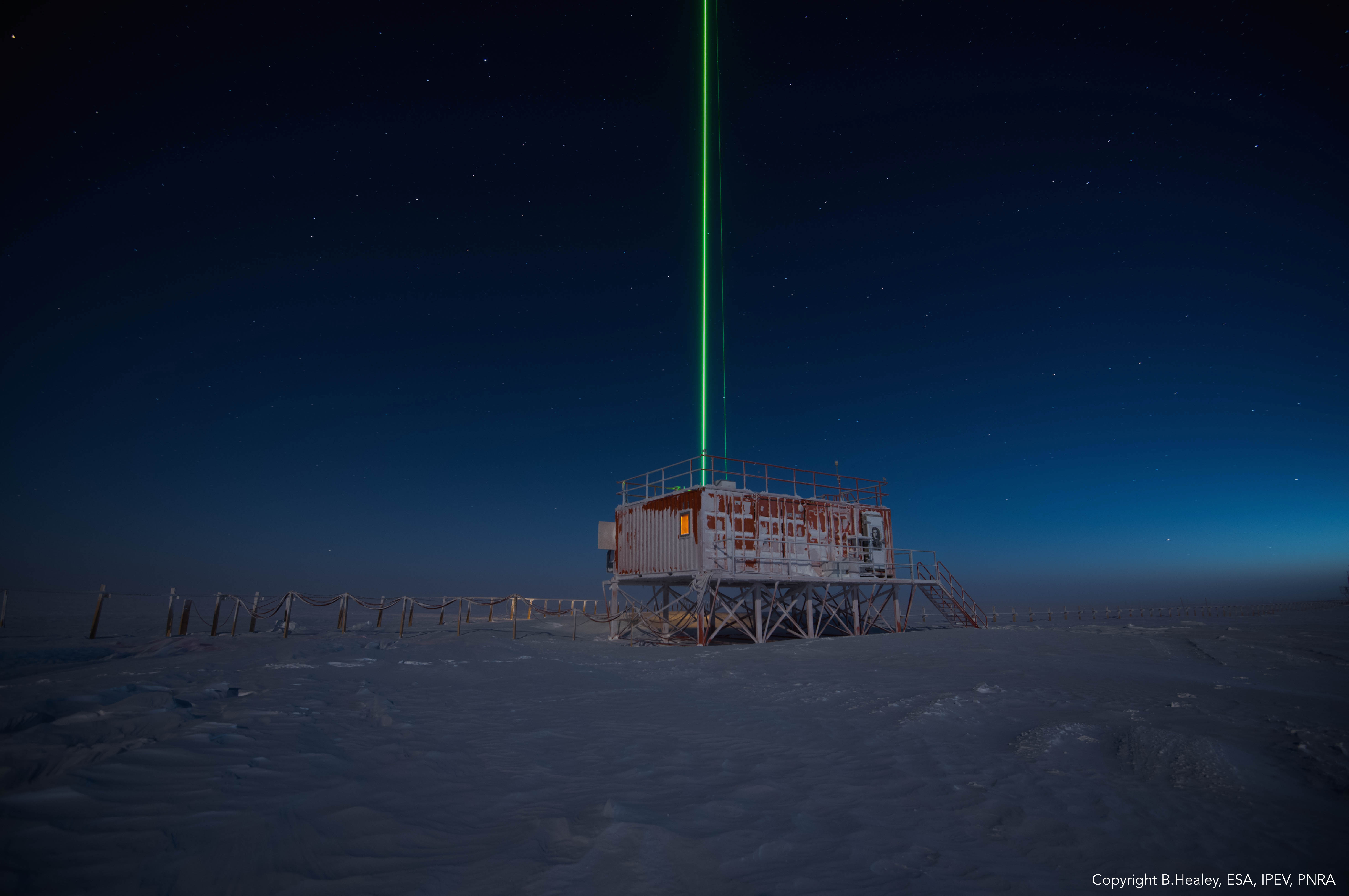
Observations of polar stratospheric clouds (PSCs) at the lidar observatory of McMurdo station.
The lidar observatory at Mcmurod, was one of the primary stations of the NDACC network (Network for the Detection of Atmospheric Composition Change) from 2004 to 2010. The lidar observes polar stratospheric clouds at a height between 12 and 26 km typically, from early June until the end of Settember. These PSCs play an important role in the ozone chemistry and promote the depletion of the stratospheric ozone layer. The lidar can detect even very thin PSC layers and can provide important information about their chemical composition. The lidar can be used to study formation and dynamical processes and to provide long term records useful for climate studies.
Simple
Identification info
Identifier
- Status
- Deprecated
Principal investigator
Point of contact
- Spatial representation type
- Text, table
Spatial resolution
Equivalent scale
- Denominator
- 5000
- Topic category
-
- Climatology, meteorology, atmosphere
Extent
N
S
E
W
))
- GCMD - Instruments
-
- LIDAR
- GCMD - Locations
-
- ANTARCTICA
- GCMD - Platforms
-
- GROUND-BASED OBSERVATIONS
- GCMD - Science Keywords
-
- POLAR STRATOSPHERIC CLOUDS/NACREOUS
- ATMOSPHERE
- LIDAR
- CLIMATE CHANGE IMPACT ASSESSMENT MODELS
- CLOUD CONDENSATION NUCLEI
- AEROSOLS
- GCMD - Providers
-
- IT/PNRA
- PNRA project
-
- OSS-12 PNRA14_00127
Resource constraints
- Use constraints
- License
- Other constraints
- CC BY-NC-SA 4.0
Associated resource
- Title
- PNRA
- Association Type
- Dependency
- Initiative Type
- Project
Associated resource
- Title
- Since 29° Italian Expedition to Antarctica
- Date (Validity Begins)
- 2013-10-01
- Date (Validity Expires)
- 2014-02-28
- Edition
- 29
- Association Type
- Dependency
- Initiative Type
- Campaign
- Language
- English
- Character encoding
- UTF8
Distribution Information
- Distribution format
-
- ASCII
- OnLine resource
-
Data resource
Link to external resource
- OnLine resource
- PNRA project: LIDAR
Data quality info
- Hierarchy level
- Dataset
Report
Result
- Title
- COMMISSION REGULATION (EU) No 1089/2010 of 23 November 2010 implementing Directive 2007/2/EC of the European Parliament and of the Council as regards interoperability of spatial data sets and services
- Date (Publication)
- 2010-12-08
- Explanation
- This data set is conformant with the INSPIRE Implementing Rules for the interoperability of spatial data sets and services
- Pass
- true
Resource lineage
- Statement
- Raw data are collected routinely by the lidar data acquisition system and successively elaborated and uploaded to the NDACC data base, usually at the end of the winter season.
- Hierarchy level
- Dataset
Reference System Information
Identifier
- Code
- WGS84
Metadata
- Metadata identifier
- urn:uuid/71fca3c3-0a5e-45a3-801d-f90fa8ea8346
- Language
- English
- Character encoding
- UTF8
Point of contact
Type of resource
- Resource scope
- Dataset
- Metadata linkage
- https://antarcticdatacenter.cnr.it/geonetwork/srv/api/records/71fca3c3-0a5e-45a3-801d-f90fa8ea8346
- Date info (Creation)
- 2020-10-27T10:23:31
- Date info (Revision)
- 2024-10-17T09:18:40
Metadata standard
- Title
- ISO 19115-3
Overviews
lidar.jpg
Spatial extent
N
S
E
W
Provided by

Associated resources
Not available