Near-surface snow density at Concordia Station, Antarctica
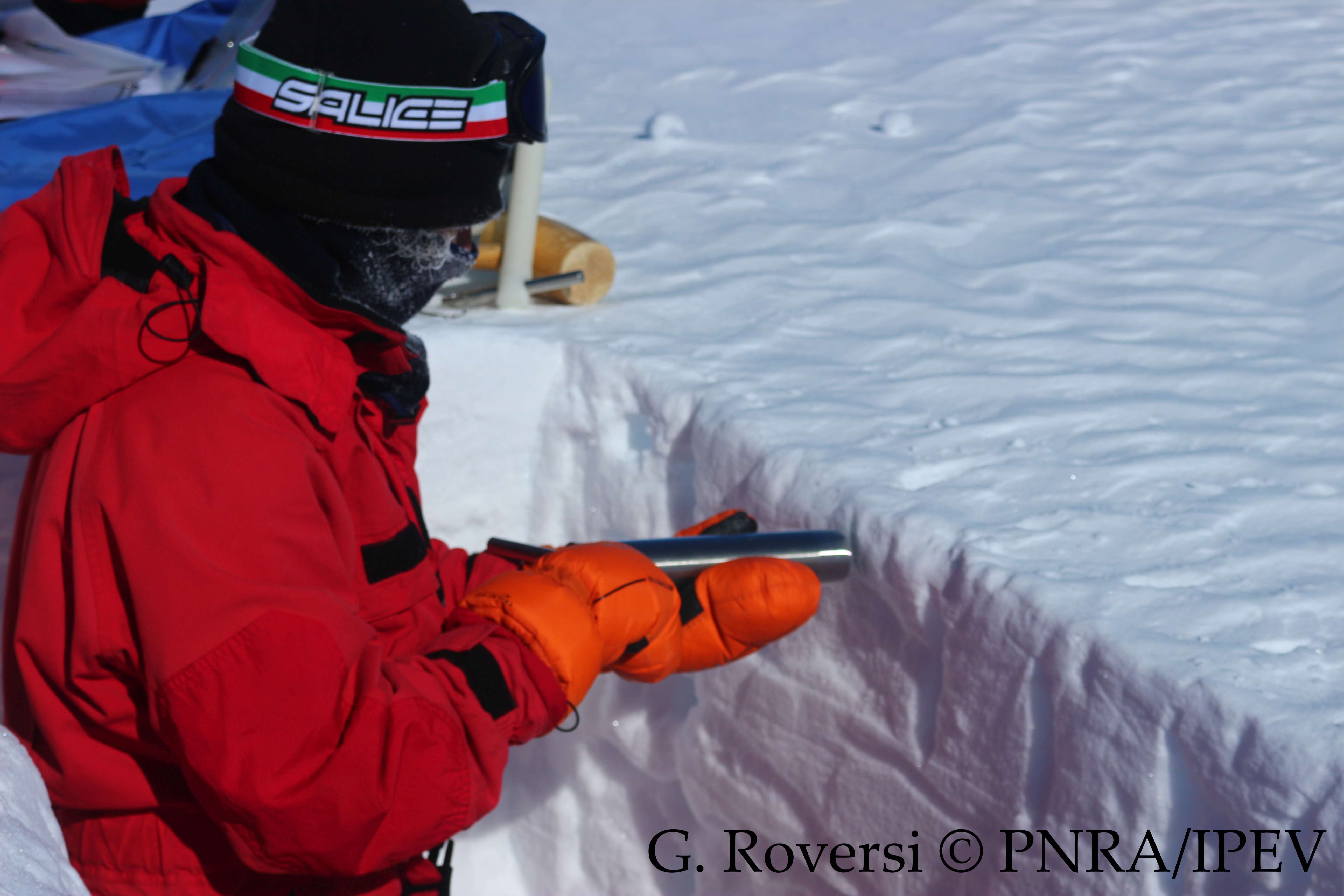
This dataset reports the snow density observations at the Concordia Station, Antarctica. A snow trench is dig once per month (or every three months during winter) in the clean area near the Station (< 1 km). Four measurements are taken inserting a core barrel (with a diameter of 4.5 cm and a length of 25 cm) horizontally into the snow at 10 cm depth, and four more measurements are taken inserting another core barrel (with a diameter of 3.7 cm and a length of 9.2 cm) vertically, from the surface to 10 cm depth. The snow density is calculated from the weight.
Simple
- Date (Creation)
- 2025-01-13
- Date (Publication)
- 2025-04-15
- Identifier
- https://antarcticdatacenter.cnr.it/geonetwork/srv/api/records/389e77f8-7648-42d0-a70d-1c77f69d8df5
- Unique resource identifier
- 10.71761/389e77f8-7648-42d0-a70d-1c77f69d8df5
- Status
- On going
- Maintenance and update frequency
- As needed
- Keywords
-
-
Antarctica, Concordia, snow, density
-
-
GCMD - Science Keywords
-
-
SNOW DENSITY
-
GLACIER MASS BALANCE/ICE SHEET MASS BALANCE
-
GLACIERS/ICE SHEETS
-
SNOW
-
-
GEMET - INSPIRE themes, version 1.0
-
-
Geology
-
Meteorological geographical features
-
-
GCMD - Locations
-
-
ANTARCTICA
-
-
Research Organization
-
-
Università Ca' Foscari di Venezia
-
-
SCAR Gazetteer of Antarctica
-
-
Concordia Station
-
Antarctica
-
-
GCMD - Providers
-
-
IT/PNRA
-
- Use limitation
- Creative-Commons CC BY-NC-SA 4.0
- Spatial representation type
- Text, table
- Denominator
- 1
- Metadata language
- English
- Character set
- UTF8
))
- Begin date
- 2023-01-06T00:00:00Z
- End date
- 2024-12-28T00:00:00Z
- Unique resource identifier
- WGS84
- Distribution format
-
-
ERDDAP
(
)
-
ERDDAP
(
)
- OnLine resource
-
Landing page
(
WWW:LINK-1.0-http--link
)
Metadata landing page
- OnLine resource
-
OPeNDAP URL
(
WWW:LINK-1.0-http--opendap
)
Link to OPeNDAP URL
- OnLine resource
-
Direct download
(
WWW:DOWNLOAD-1.0-http--download
)
Download a CSV version
- OnLine resource
-
Direct download
(
WWW:DOWNLOAD-1.0-http--download
)
Download a NetCDF version
- OnLine resource
- Digital Object Identifier (DOI) ( DOI )
- Hierarchy level
- Dataset
Domain consistency
Conformance result
- Date (Publication)
- 2010-12-08
- Explanation
-
This data set is conformant with the INSPIRE Implementing Rules for the interoperability of spatial data sets and services
- Pass
- Yes
- Statement
-
2025-01-13T09:45:00Z First upload of the dataset
- File identifier
- 389e77f8-7648-42d0-a70d-1c77f69d8df5 XML
- Metadata language
- English
- Character set
- UTF8
- Hierarchy level
- Dataset
- Date stamp
- 2025-05-12T14:21:06
- Metadata standard name
-
ISO 19139
- Metadata standard version
-
1.0
Overviews
Spatial extent
Provided by