Meteorological geographical features
Type of resources
Available actions
Topics
INSPIRE themes
Keywords
Contact for the resource
Provided by
Years
Formats
Representation types
Update frequencies
status
Scale
-

This dataset reports the height observations of the Italian stake farm at the Concordia Station, Antarctica. The stake farm consists of 13 stakes, separated from each other by 10 m, arranged in a cross shape structure, located approximately 800m southwest of the Station and sampled on monthly basis or so.
-
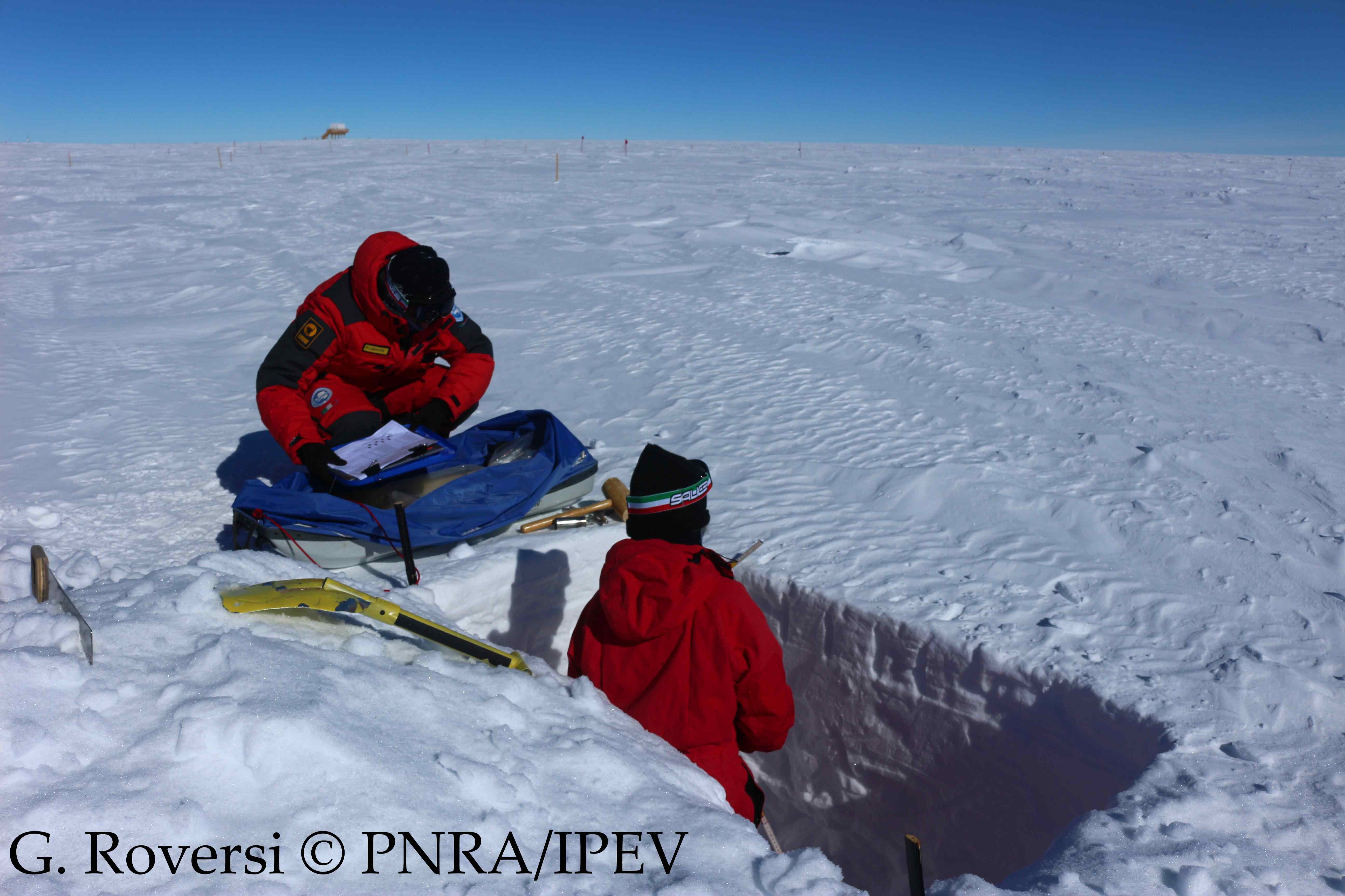
This dataset reports the snow density, temperature and hardness observations from the surface to 1 m depth at the Concordia Station, Antarctica. A snow trench is dig once per month (or every three months during winter) in the clean area near the Station (< 1 km). The snow density measurements are taken inserting a core barrel (with a diameter of 4.5 cm and a length of 25 cm) horizontally into the snow every 10 cm from 0 to 1 m depth. The snow density is calculated from the weight. For each layer the temperature and the hardness (ranging from 1 to 6) are also recorded.
-
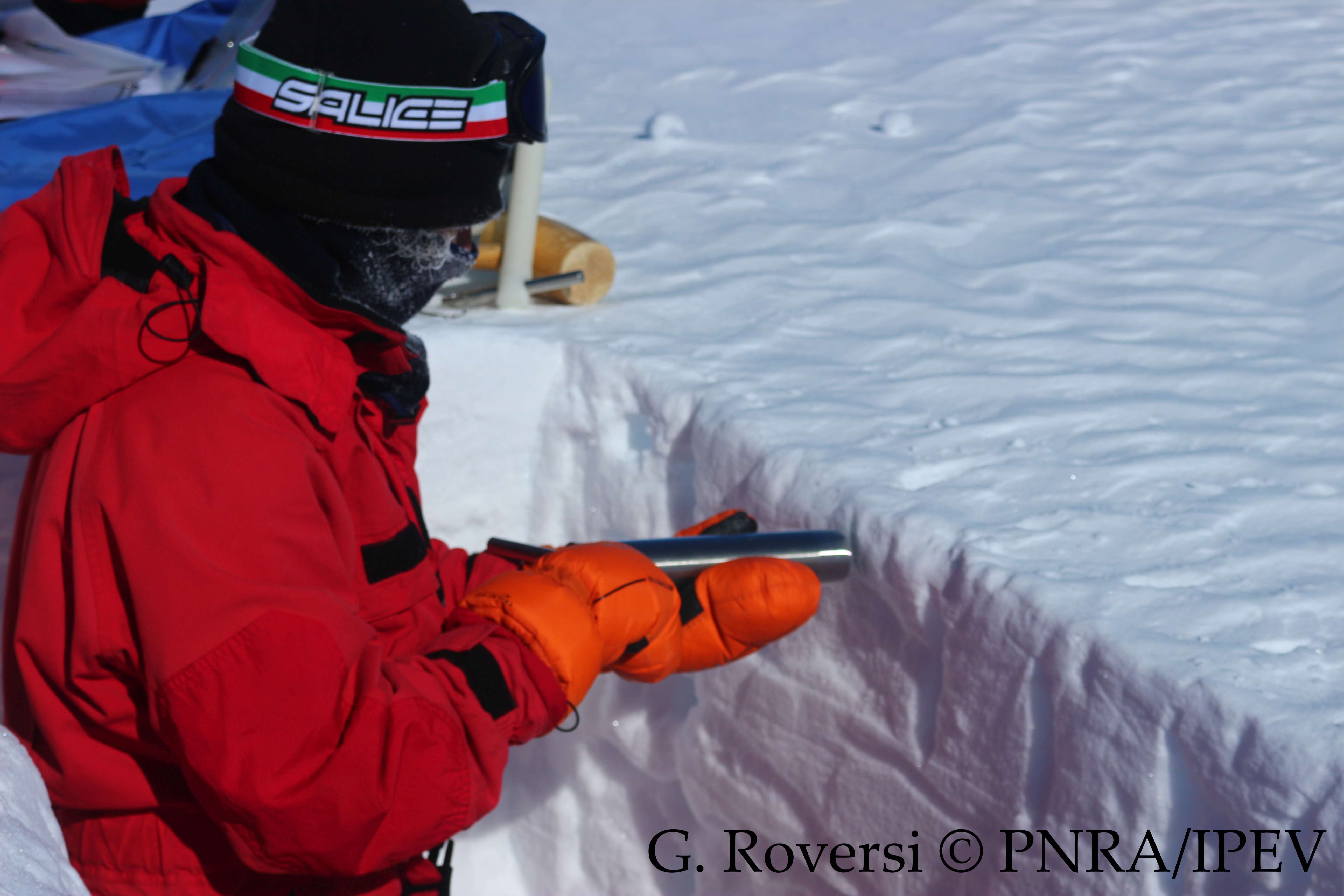
This dataset reports the snow density observations at the Concordia Station, Antarctica. A snow trench is dig once per month (or every three months during winter) in the clean area near the Station (< 1 km). Four measurements are taken inserting a core barrel (with a diameter of 4.5 cm and a length of 25 cm) horizontally into the snow at 10 cm depth, and four more measurements are taken inserting another core barrel (with a diameter of 3.7 cm and a length of 9.2 cm) vertically, from the surface to 10 cm depth. The snow density is calculated from the weight.
-
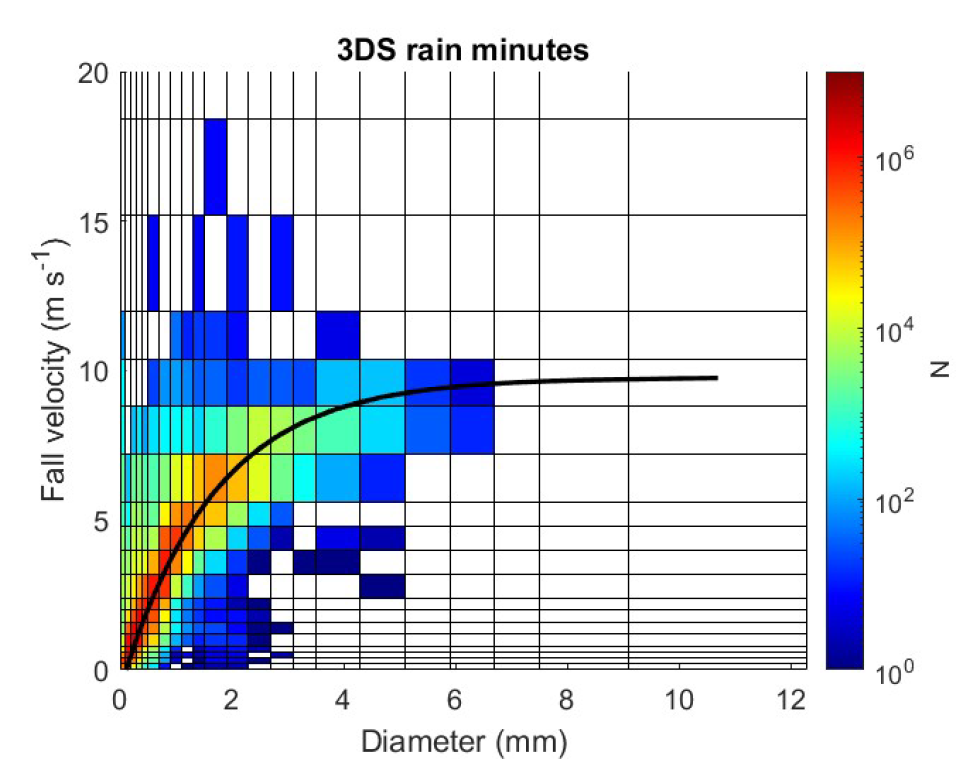
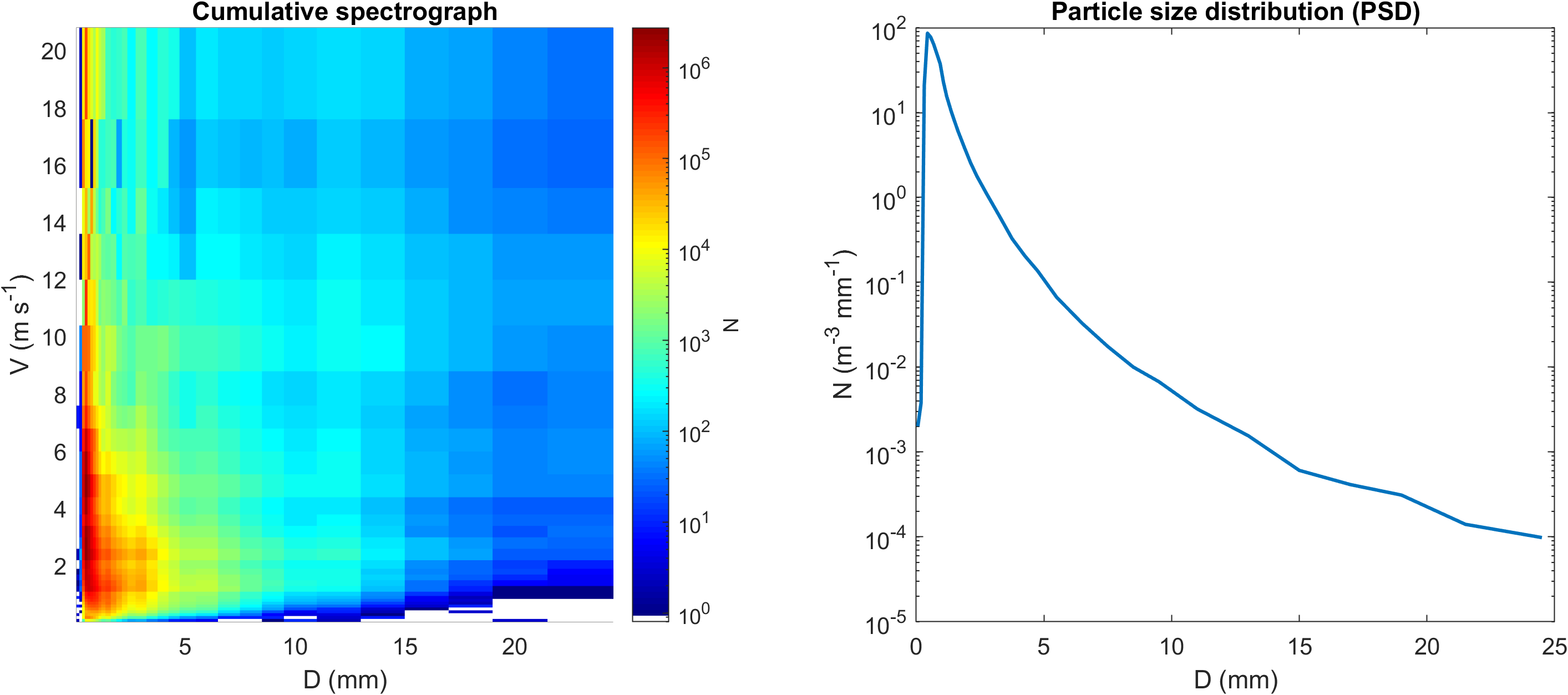
Disdrometric data from a Thies Clima 3D Stereo with 22 size classes and 20 velocity classes positioned at L'Aquila (Italy, 42.3831 N, 13.3148 E, 683 m a.s.l.), with monthly spectra and ancillary information.
-
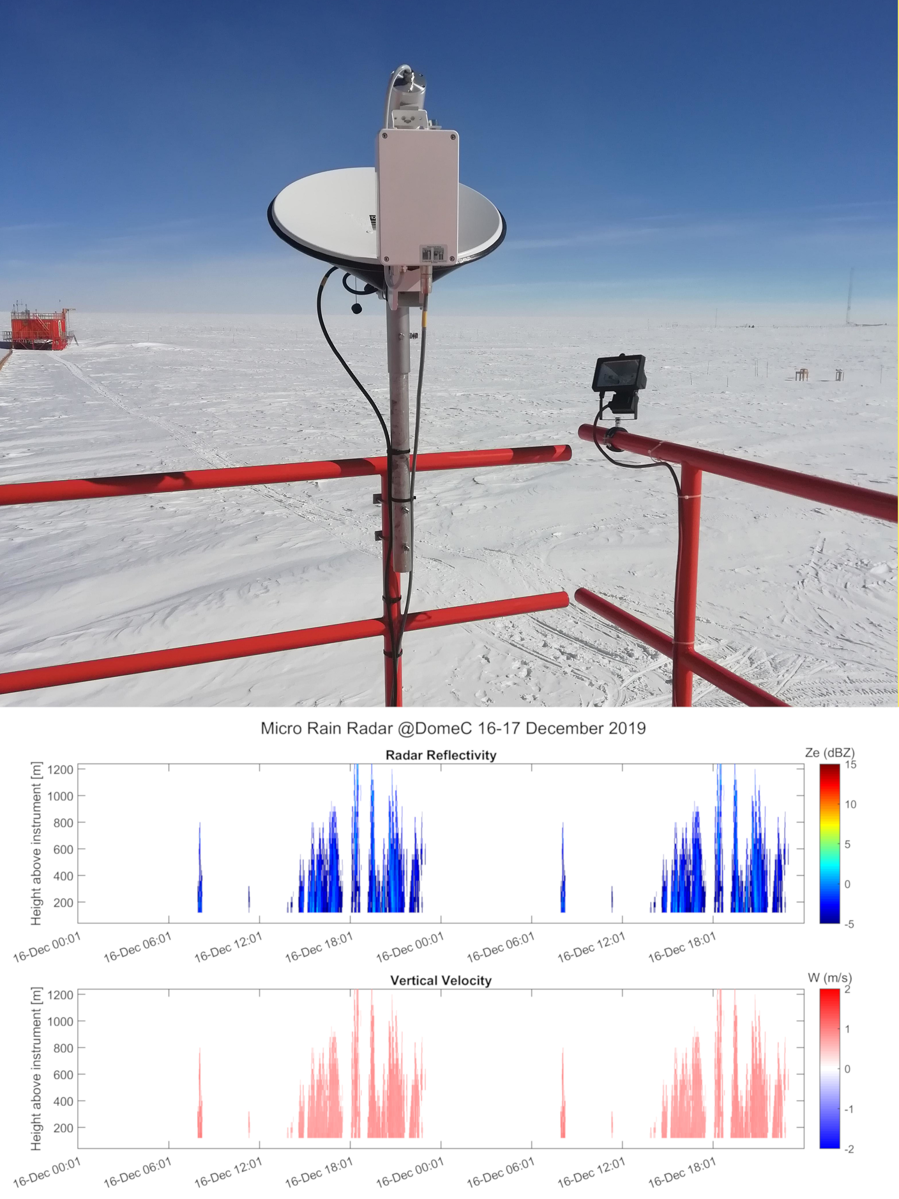
Vertical profiles along the first three kilometres of atmosphere above the ground (from 300 to 3000 m a.g.l.) of equivalent radar reflectivity factor (Ze), Doppler velocity (W) and Doppler spectral width (Sw) from a 24-GHz vertically pointing Micro Rain Radar MRR-2 by METEK GmbH positioned at Concordia Station (Dome C, Antarctica). The main objective of the FIRCLOUDS project is a complete spectral characterization of cirrus and mixed phase clouds in order to evaluate the radiative models in the FIR regime, where the clouds effect is very strong, and systematic spectral measurements are scarcely available. The micro rain radar (MRR) data allows the determination of the clouds reflectivity and the vertical velocity of ice crystals in the cases of precipitating clouds.
-

Pictures of the ice camera and the halo camera positioned at Concordia Station (Dome C, Antarctica). Data are available on the INO-CNR server on request to Dr. Massimo Del Guasta. The main objective of the FIRCLOUDS project is a complete spectral characterization of cirrus and mixed phase clouds in order to evaluate the radiative models in the FIR regime, where the clouds effect is very strong, and systematic spectral measurements are scarcely available. The ice and halo imager cameras enable an assessment of the cloud ice crystals micro-physics.
-
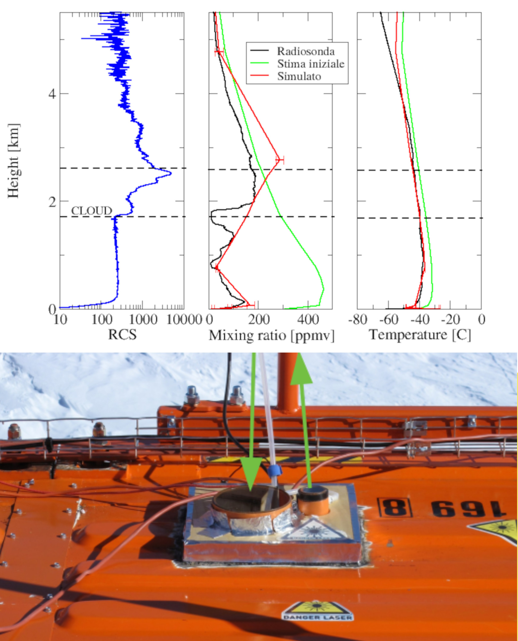
Backscattering and depolarization data from a LIDAR positioned at Concordia Station (Dome C, Antarctica). Data are available on the INO-CNR server on request to Dr. Massimo Del Guasta. The main objective of the FIRCLOUDS projectis a complete spectral characterization of cirrus and mixed phase clouds in order to evaluate the radiative models in the FIR regime, where the clouds effect is very strong, and systematic spectral measurements are scarcely available. A backscattering/depolarization lidar contributes to the estimation of the clouds position and phase, and of the optical extinction profile.
-
Disdrometric data from an OTT Parsivel with 32 size classes and 32 velocity classes positioned at Mario Zucchelli Station (Antarctica), with monthly spectra and particle size distributions (PSD).
-
The main goal of our proposal is to characterize the surface radiative budget as well as cloudiness which features at the Argentine Bases Marambio and Belgrano II during the YOPP-SH Special Observing Period (SOP) as well as the YOPP Consolidation Phase. Specific objectives to secure our main goal during the SOP will be: 1 - develop a compact Radiation Measurement UNIT (RMU) robust enough to allow continuous measurements in harsh environment through which to make shortwave, longwave observations as well as to record status of the sky. 2 - secure UV measurements at both stations. 3 - develop specific tools to analyse on a daily basis (weakly for clouds) collected data and extract parameters of interest. For radiation these will include QA/QC SW and LW downwelling and upwelling fluxes, diffuse and direct components of solar radiation, UV spectral flux and doses. For clouds these will include, on a continuous base, cloud fraction derived both from radiometric measurement and sky camera observations, cloud type and cloud effect on SW radiation. In addition cloud base (or cloud ceiling) will be obtained by routine observations performed at the two stations. From UV measurements columnar ozone content will be also derived. Moving forward to YOPP consolidation phase, we plan to: 1 - extend dataset and its analysis, start to collect information on seasonal and inter-annual variability, determine Cloud radiative Forcing (CRF) 2 - perform extensive comparison between automatic and visual cloudiness observation methods. They being very useful to better understand quality and value of historical datasets at the two stationsù 3 - make comparison with cloudiness regime of Ross Sea and Antarctic Plateau. Make similar comparison for UV fluxes in the Peninsula and at Concordia.
-
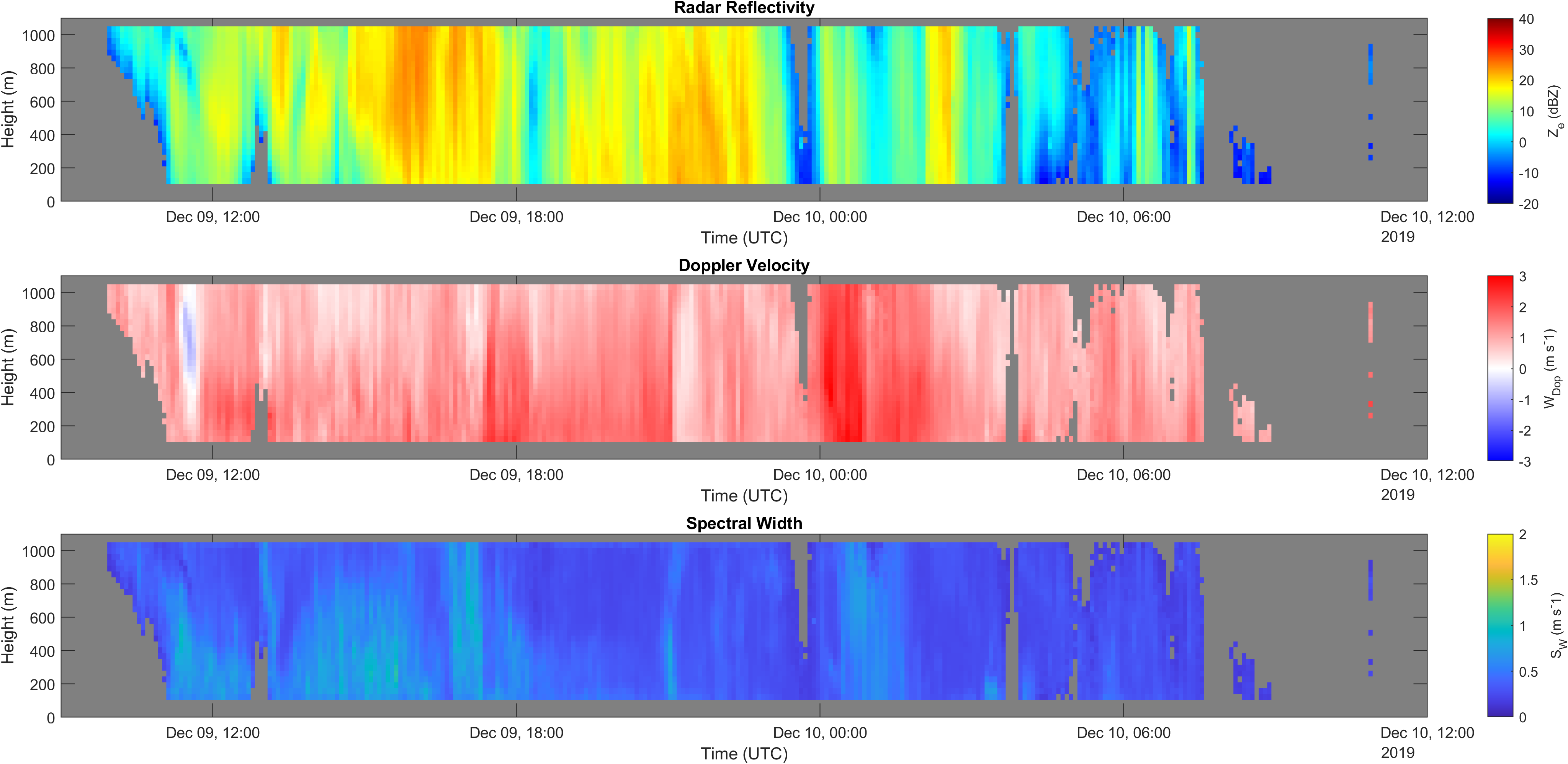
Vertical profiles along the first kilometre of atmosphere above the ground (from 105 to 1050 m a.g.l.) of equivalent radar reflectivity factor (Ze), Doppler velocity (W) and Doppler spectral width (Sw) from a 24-GHz vertically pointing Micro Rain Radar MRR-2 by METEK GmbH positioned at Mario Zucchelli Station (Antarctica).