1
Type of resources
Available actions
Topics
INSPIRE themes
Keywords
Contact for the resource
Provided by
Years
Formats
Representation types
Update frequencies
status
Scale
-
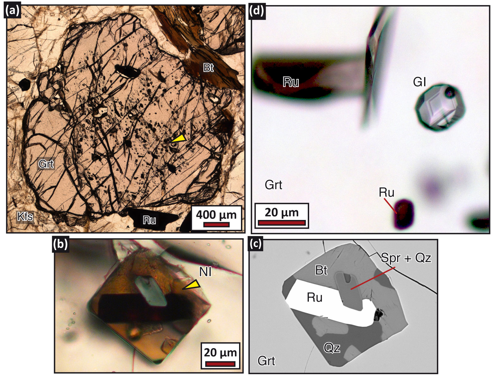
Below the results obtained by the HOT ANTARCTICA project are presented. Results regarding geochemistry of crustal melts Main results obtained by the most prominent samples are described separately for each of the investigated terranes (Napier Complex, Lützow Holm Complex, Rauer Islands and Schrimacher Hills). The methodology employed during the work is also listed below: 1) Samples interrogated in this project were previously collected from Napier Complex (provided by the collaboration with Prof. Simon Harley, University of Edinburgh), Lützow Holm Complex (provided by the collaboration with Prof. Satish-Kumar, University of Niigata), Rauer Islands (provided by the collaboration with Prof. Simon Harley, University of Edinburgh and in collaboration with Zhao Liu, Northwest University ,China) and Schrimacher Hills (provided by the Museo Nazionale dell’Antartide, Siena, Italy). 2) Microstructural and petrographic study were done in all samples to identify equilibrium assemblages, melting reaction microstructures and occurrence of nanogranitoids (i.e. crystallized inclusions), melt and fluid inclusions. 3) Microstructural characterization of inclusions using Field Emission-Scanning Electron Microscope (FE-SEM) analyses were done: i) to identify the submicrometric phases within nanogranitoids and ii) to verify the homogeneity of remelted nanogranites and preserved glassy melt inclusions. 4) Experimental remelting of crystallized melt inclusions was performed to overcome the problem of MI decrepitation and volatile loss. The remelting of nanogranitoids was performed at high pressure with a piston cylinder apparatus using a QUICKpress piston cylinder apparatus produced by Depths of the Earth (installed at the Dipartimento di Geoscienze, UniPd). 5) Analysis of the major and trace elements contents of melt inclusions was carried out using i) an electron microprobe at the at University of Milan and ii) a LAICPMS at University of Perugia. 6) Thermodynamic modeling of anatectic conditions: the evaluation of P-T-X parameters and of P-T paths in the different geologic contexts were carried out using the software Perple_X. 7) Micro-Raman spectroscopy: characterization of fluid inclusions coexisting with melt inclusions was done using a HORIBA LabRam HR (high resolution) Raman microspectrometer at the University of Pavia. 8) Cross-comparison of data: during the development of this research project all collected data were analyzed by cross-comparing the information from the different geological contexts, with the aim to highlight similarities and differences. 9) Data discussion and evaluation: all data was analyzed and discussed in tight collaboration with the researchers involved in this project. 10) Synthesis and dissemination of results: dissemination of results was done with oral and poster presentations in several international conferences (see list on the appropriate section - Atti). Presentations include invited keynote presentations by the PI, Bruna Borges Carvalho at Goldschmidt (France, 2023) and Hutton Symposium (Italy, 2023). Invited seminars were also given in several important universities around the world [University of Bern, Switzerland; University of Cambridge, UK; University of Niigata, University of Kyoto, Japan]. Furthermore, a total of two research papers have been published in journals of high impact factor, and other two articles are in preparation. Here we also provide mineral, geochemical and geochronological data of studied areas at Rundvagshetta and Rauer Islands. Preprinted versions of two published article where the data is explained are also provided. Carvalho, B.B., Bartoli, O., Cesare, B., Satish-Kumar, M., Petrelli, M., Kawakami, T., Hokada, T., Gilio, M. (2023). Revealing the link between A-type granites and hottest melts from residual metasedimentary crust. Geology 51, 845-849. https://doi.org/10.1130/G51097.1 Liu, Z., Carvalho, B.B., Li, W., Tong, L., Bartoli, O., Li, C., Chen, L., ,Yan, Q, Wu, H. 2023. Into the high to ultrahigh temperature melting of Earth’s crust: Investigations of melt and fluid inclusions within Mg–rich metapelitic granulites from the Mather Peninsula, East Antarctica. Journal of Petrology 64, egad051. https://doi.org/10.1093/petrology/egad051 Results regarding petrology and geochronology of granulites In northern Victoria Land, the presence of two contrasting P-T paths suggests the possibility that high-grade complexes could have experienced a different metamorphic evolution both in space and time. Geochronological data of the Granite Harbour Intrusives support a prolonged magmatic activity (540-480 Ma), with multiple igneous pulses. This could imply the existence of magmatic underplating triggering the development of monometamorphic granulites during the Ross Orogeny. On the other hand, structural and PT evolution suggest the presence of a polymetamorphic granulitic belt that could be remnant of older orogeny as the Panafrican (ca. 600-500 Ma) (Lombardo et al., 1987; Palmeri, 1997; Talarico and Castelli, 1995). In order to discriminate mono- from poly-metamorphic evolution, metasedimentary granulite complex from the Deep Freeze Range has been investigated. Among all available granulite samples, a detailed petrographical study has been conducted to select the most representative and suitable HT granulite-facies rocks: four samples have been individuated for petrological and geochronological analyses (Opx-Grt and >30 µm Zrn/Mnz bearing), fifteen for geochemistry (absence of leucosome). In the Deep Freeze Range, HT granulites consist of Grt-Opx±Bt±Crd±Spl±Crn gneisses characterized by the presence of numerous Opx±Grt leucocratic segregations. Geochemical results confirm that analyzed granulite protholites have sedimentary origin, being comparable to Post Archean Australian Shale (PAAS; Taylor and McLennan, 1985), and they have been deposited in an orogenic setting (active continental margin). Petrographical, microstructural and mineral chemistry analyses show a metamorphic evolution including three different stages: Pl-Grt1-Spl-Crn-Ilm medium-P granulite facies (M1), Qtz-Pl-Opx-Grt1-Crd-Ilm-Kfs low-P granulite facies (M2), and Qtz-Pl-Grt2-Kfs-Bt-Ath low-P amphibolite (M3). Preliminary petrological results indicate that evolving metamorphic parageneses describe an initial isothermal decompression (exhumation event) followed by isobaric cooling; further thermodynamic modeling by software Perple_X will allow to better define P-T-X conditions. Geochronological studies involved the observation and analysis of monazites and zircons on four selected granulite thin sections. Investigations included X-ray mapping carried out under the electron microscope, CL-BSE imaging (zircons), and trace element analysis and U-Pb dating using LA-ICP-MS. Acquired data are still under review and will have a fundamental role in the reconstruction of the P-T-t path, thus making it possible to discriminate between mono- and poly-metamorphic hypotheses. References Lombardo et al 1987. Memorie della Società Geologica Italiana 33, 99-130. Palmeri R. 1997. Lithos 42, 47-66. Talarico and Castelli D. 1995. Precamb. Res. 75, 157-174. Taylor and McLennan S.M. 1985. Blackwell, Oxford, 312 p.
-
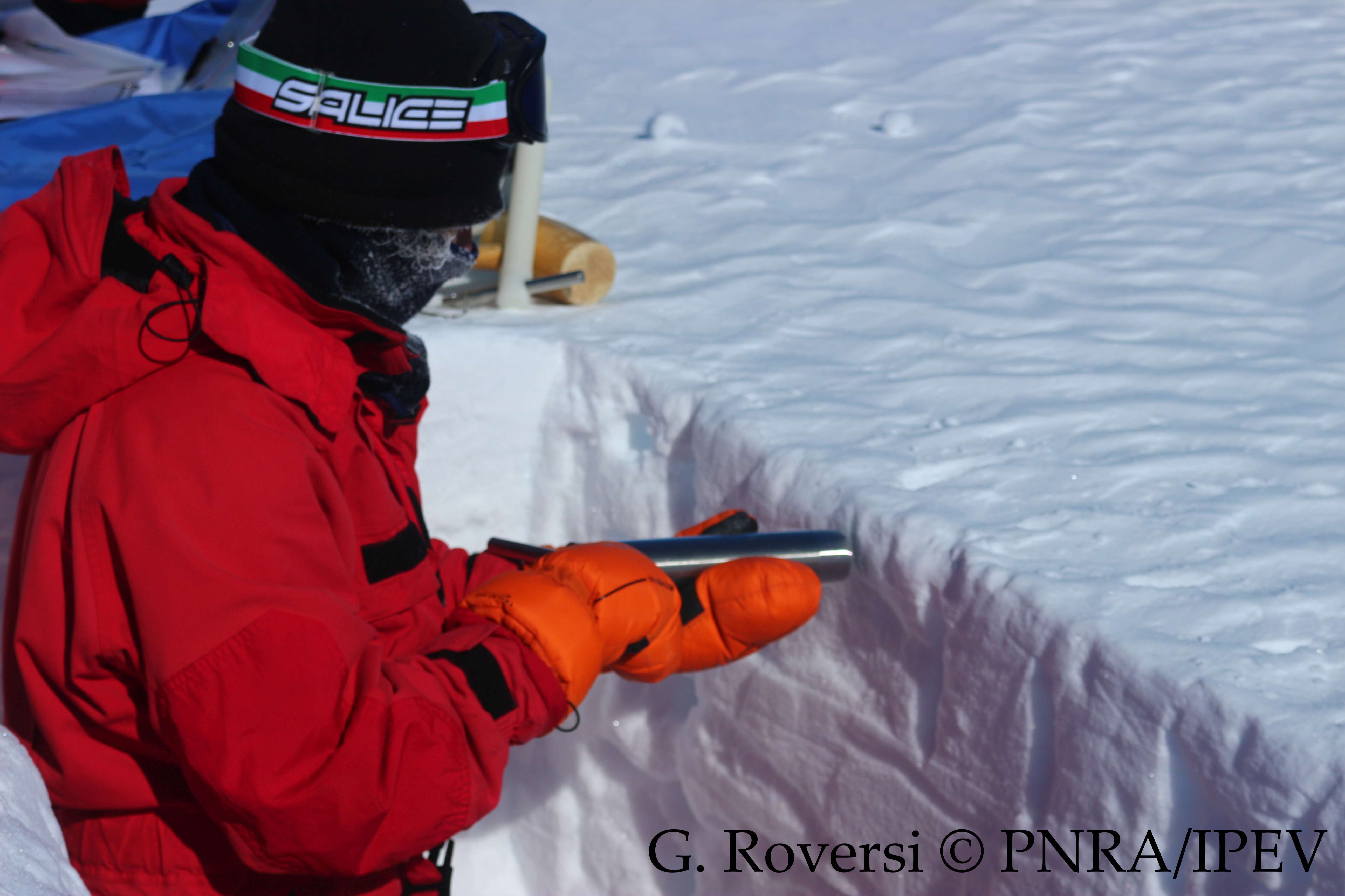
This dataset reports the snow density observations at the Concordia Station, Antarctica. A snow trench is dig once per month (or every three months during winter) in the clean area near the Station (< 1 km). Four measurements are taken inserting a core barrel (with a diameter of 4.5 cm and a length of 25 cm) horizontally into the snow at 10 cm depth, and four more measurements are taken inserting another core barrel (with a diameter of 3.7 cm and a length of 9.2 cm) vertically, from the surface to 10 cm depth. The snow density is calculated from the weight.
-

The datataset includes sound pressure levels acquired in the Ross Sea during project AMORS
-
Anthropogenic microparticles (AMs) were found for the first time in specimens of Trematomus bernacchii collected in 1998 in the Ross Sea (Antarctica) and stored in the Antarctic Environmental Specimen Bank. Most of the identified AMs were fibers of natural and synthetic origin. The natural AMs were cellulosic, the synthetic ones were polyester, polypropylene, polypropylene/polyester, and cellulose acetate. The presence of dyes in the natural AMs indicates their anthropogenic origin. Five industrial dyes were identified by Raman spectroscopy with Indigo occurring in most of them (55%). Our research not only adds further data to the ongoing knowledge of pollution levels in the Antarctic ecosystem, it provides an interesting snapshot of the past, highlighting that microplastics and anthropogenic fiber pollution had already entered the Antarctic marine food web at the end of the ‘90 s. These findings therefore establish the foundations for understand the changes in marine litter pollution over time.
-
Surface ozone data, collected through a UV-absorption analyzer (49i or 49c)
-
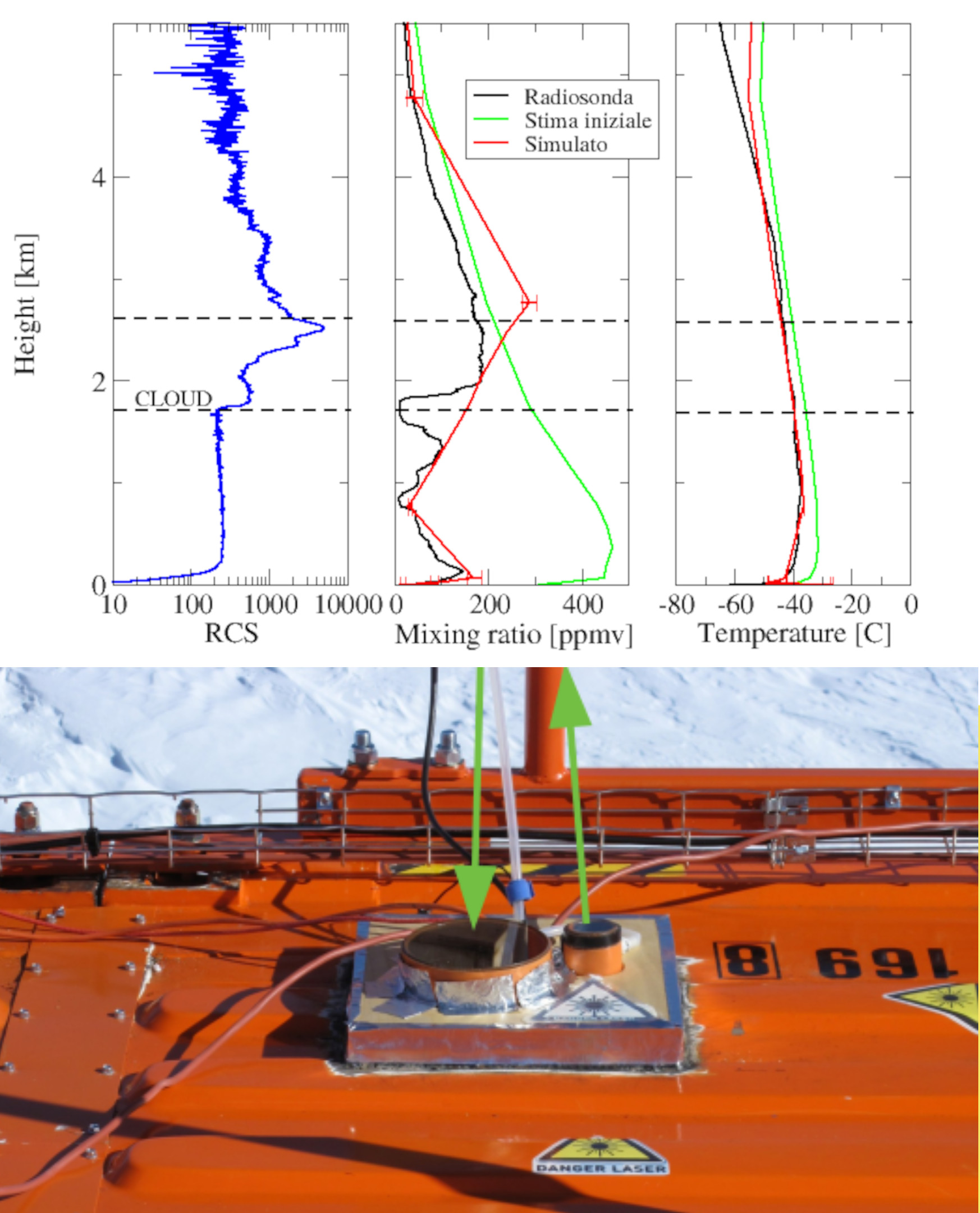
Backscattering and depolarization data from a LIDAR positioned at Concordia Station (Dome C, Antarctica). Data are available on the INO-CNR server on request to Dr. Massimo Del Guasta. The main objective of the FIRCLOUDS projectis a complete spectral characterization of cirrus and mixed phase clouds in order to evaluate the radiative models in the FIR regime, where the clouds effect is very strong, and systematic spectral measurements are scarcely available. A backscattering/depolarization lidar contributes to the estimation of the clouds position and phase, and of the optical extinction profile.
-
This dataset contains a selection of bias-corrected data from the preoperational MiKlip system for decadal climate predictions (Mueller et al., 2018) used within the project PNRA18_00199-IPSODES. The adopted method for bias correction is described in the file bias_correction.pdf attached to the dataset. Also data from the assimilation run are provided. Nomenclature of variables follows that of the original MiKlip output. Mueller, W., et al. A Higher‐resolution Version of the Max Planck Institute Earth System Model (MPI‐ESM1.2‐HR). J. Adv. Model. Earth Syst. 10, 1383-1413 (2018)
-
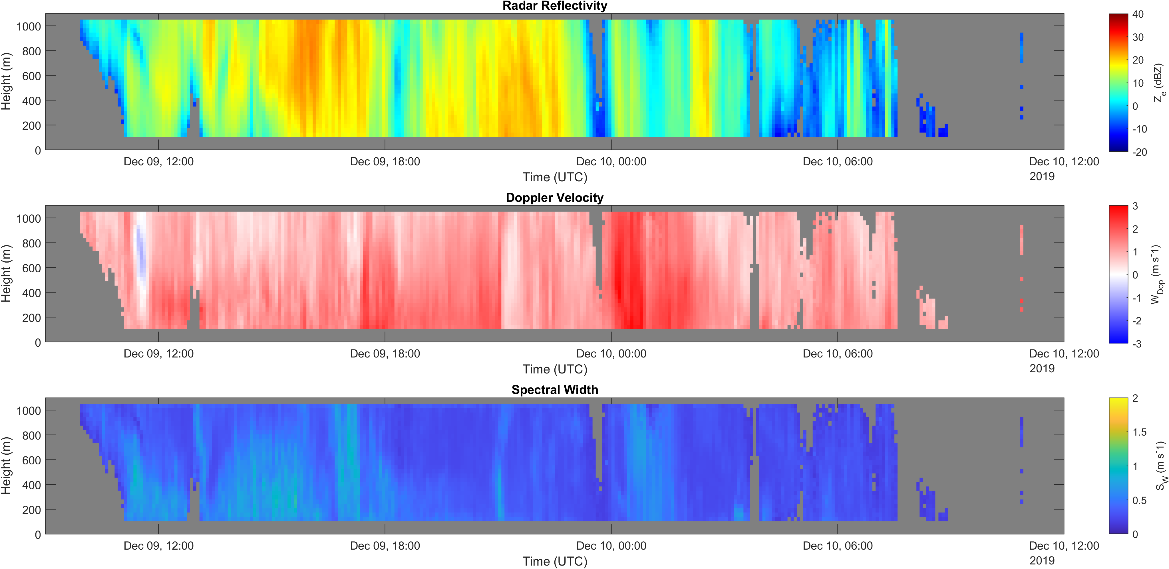
Vertical profiles along the first kilometre of atmosphere above the ground (from 105 to 1050 m a.g.l.) of equivalent radar reflectivity factor (Ze), Doppler velocity (W) and Doppler spectral width (Sw) from a 24-GHz vertically pointing Micro Rain Radar MRR-2 by METEK GmbH positioned at Mario Zucchelli Station (Antarctica).
-
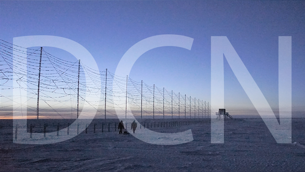
The HF radar denominated Dome C North (DCN) emits pulses of HF waves (8–20 MHz) which are refracted in the ionosphere and can be back-scattered by field aligned decameter scale irregularities of the electron density at distances ranging from 180 to 3550 km from the radar and at heights between 100 and 400 km. The radar signals are steered in 16 emission beams, separated by 3.3 degrees, in an azimuthal interval of 52 degrees, usually swept in 2 minutes. The signals are emitted according to multi-pulse sequences that allow the real-time acquisition of the autocorrelation function of the back scatter echoes, from which the reflected power, the VD Doppler velocity of the irregularities, and the spectral width can be calculated for each distance-azimuth cell. VD coincides with the velocity of the plasma along the line of sight. DCN is part of the Super Dual Auroral Radar Network (SuperDARN). In SuperDARN, pairs of radars, typically located at 2000 km distance and oriented so that their beams cross each other over the region to be studied, are used to get the velocity vector in two dimensions. DCN forms a common-volume pair with the SuperDARN Zhongshan radar (China). SuperDARN radars are devoted to the study of ionosphere, between 100 and 400 km from ground, in the polar, auroral and medium latitude regions. The sscientific objectives of SuperDARN and DCN span from fundamental plasma physics to space weather, in the framework of Sun-Earth relations. Italy participates in the SuperDARN international network also with the Dome C East (DCE) radar,installed at Concordia in 2013 and operative since then.
-
The Concordia Research Station provides a unique location for preparatory activities for future human journey to Mars, to explore microbial diversity at subzero temperatures and monitor the dissemination of human-associated microorganisms within the pristine surrounding environment. The present study was performed in the frame of the BacFinder project (European Space Agency, ESA AO-13-Concordia) with the aim to unravel the environmental- and human-associated microbial diversity in the surrounding of the Concordia Station. This is the first intensive and extensive surface snow sampling performed monthly over a two-year period at three distances (10, 500, and 1000 m) from the Concordia Station, and investigated by a high-throughput sequencing approach. Emphasis was laid on the relation between microbial presence and both seasonality and distance from the Base. Data suggested that if present the anthropogenic impact was below the detection limit of the employed DNA sequencing-based techniques. On the other hand, our study corroborated the use of DNA sequencing for revealing microbial presence in remote and hostile environments, with implications for Planetary Protections and for life-detection in astrobiology relevant targets.