Type of resources
Available actions
Topics
INSPIRE themes
Keywords
Contact for the resource
Provided by
Years
Formats
Representation types
Update frequencies
status
Scale
-

The datataset includes sound pressure levels acquired in the Ross Sea during project AMORS
-
Surface ozone data, collected through a UV-absorption analyzer (49i or 49c)
-
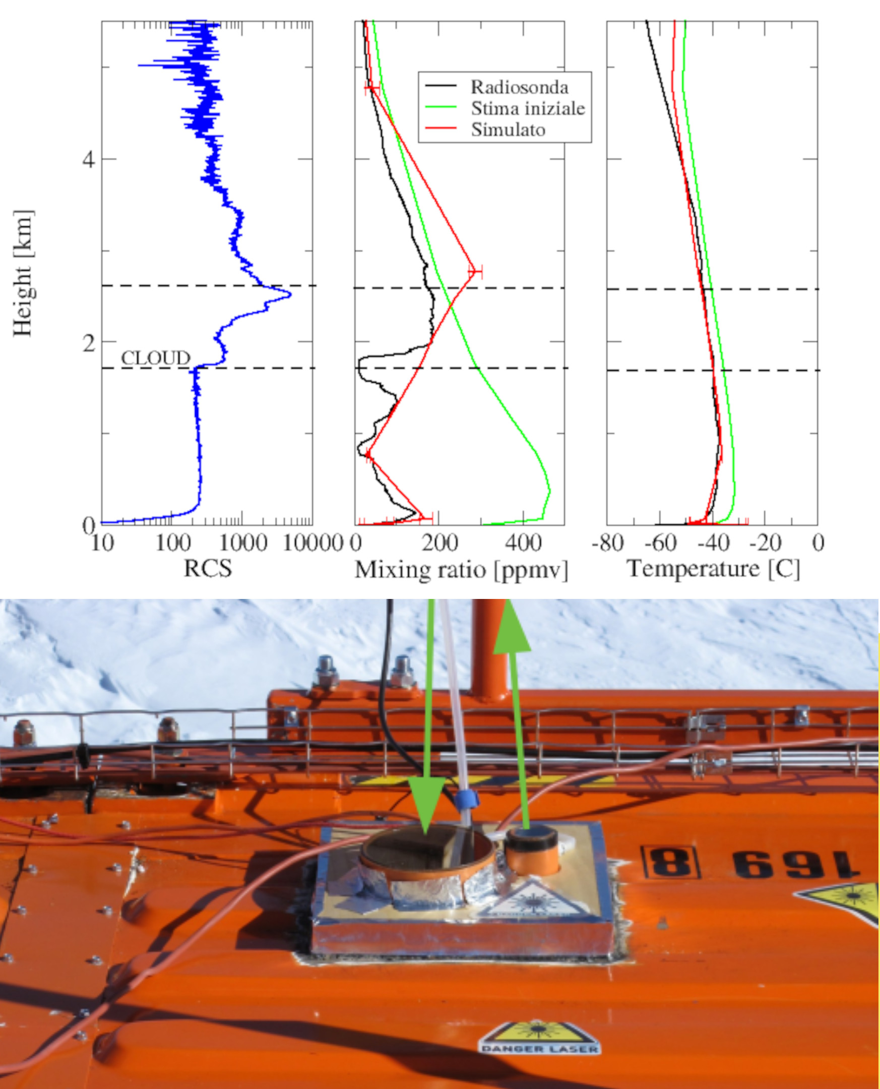
Backscattering and depolarization data from a LIDAR positioned at Concordia Station (Dome C, Antarctica). Data are available on the INO-CNR server on request to Dr. Massimo Del Guasta. The main objective of the FIRCLOUDS projectis a complete spectral characterization of cirrus and mixed phase clouds in order to evaluate the radiative models in the FIR regime, where the clouds effect is very strong, and systematic spectral measurements are scarcely available. A backscattering/depolarization lidar contributes to the estimation of the clouds position and phase, and of the optical extinction profile.
-
The Concordia Research Station provides a unique location for preparatory activities for future human journey to Mars, to explore microbial diversity at subzero temperatures and monitor the dissemination of human-associated microorganisms within the pristine surrounding environment. The present study was performed in the frame of the BacFinder project (European Space Agency, ESA AO-13-Concordia) with the aim to unravel the environmental- and human-associated microbial diversity in the surrounding of the Concordia Station. This is the first intensive and extensive surface snow sampling performed monthly over a two-year period at three distances (10, 500, and 1000 m) from the Concordia Station, and investigated by a high-throughput sequencing approach. Emphasis was laid on the relation between microbial presence and both seasonality and distance from the Base. Data suggested that if present the anthropogenic impact was below the detection limit of the employed DNA sequencing-based techniques. On the other hand, our study corroborated the use of DNA sequencing for revealing microbial presence in remote and hostile environments, with implications for Planetary Protections and for life-detection in astrobiology relevant targets.
-
The larval stages can be considered as the link from plankton to benthos. In order to study larval recruitment from zoobenthos, 40 tiles were placed at each of the four sites outlined in the project: Tethys Bay (control), Rod Bay (area subject to anthropogenic impact), Faraglione (control) and Adelie Cove (area subject to natural impact, linked to the presence of a penguin house). Due to adverse environmental factors all the tiles from Faraglione were lost and from Tethys Bay only half were found. The tiles were analysed with the help of a binocular, which enabled better visualisation of the organisms and, consequently, better identification.
-
Basic and other measurements of radiation at Concordia Station during "November" "2018": for other details see the full metadata description at https://doi.pangaea.de/10.1594/PANGAEA.896816
-
Calibrated (in unit of solar disk brightness) measurements of the sky brightness at DOME C as obtained by the ESCAPE experiment during the campaign 2021-2022
-
Here we present the firn cores collected along the international EAIIST project traverse, which took place in 2019-2020 Antarctic Campaign. We report the number of firn cores collected, the depth of the samplings and their geographic information.
-

Pictures of the ice camera and the halo camera positioned at Concordia Station (Dome C, Antarctica). Data are available on the INO-CNR server on request to Dr. Massimo Del Guasta. The main objective of the FIRCLOUDS project is a complete spectral characterization of cirrus and mixed phase clouds in order to evaluate the radiative models in the FIR regime, where the clouds effect is very strong, and systematic spectral measurements are scarcely available. The ice and halo imager cameras enable an assessment of the cloud ice crystals micro-physics.
-
Calibrated (in unit of solar disk brightness) measurements of the sky brightness at DOME C as obtained by the ESCAPE experiment during the campaign 2019-2020