asNeeded
Type of resources
Available actions
Topics
INSPIRE themes
Keywords
Contact for the resource
Provided by
Years
Formats
Representation types
Update frequencies
status
Scale
-
Terra Nova Bay (Ross Sea, Antarctica), characterized by a moltitude of ice tongues flowing from land to sea, represents an ideal study site for understanding the complex interaction between relative sea level variations and ice sheet dynamics during the Holocene. The DISGELI project, thanks to the combination of innovative technology and traditional methods for geomorphologic and stratigraphic analysis, aims to: i) reconstruct the local variations of the East Antarctic Ice Sheet after the Last Glacial Maximum; ii) provide a time constrain for the deglaciation processes along the coast; iii) reconstruct, with unprecedent detail, the relative sea level variations during Holocene in the Drygalski basin. The morpho-bathymetric and topographic data obtained through this study will be integrated using digital terrain models based on the analyses of key areas onland, where palaeo-coastlines and sea-level markers have been identified.
-
Calibrated (in unit of solar disk brightness) measurements of the sky brightness at DOME C as obtained by the ESCAPE experiment during the campaign 2019-2020
-
The data are related to the ionic composition of atmospheric aerosol continuously collected at Dome C. They refer to PM10 and size-segregated aerosol collected at 2-day and 4-day resolution, respectively. The measured chemical parameters include main and trace inorganic anions and cations and selected organic anions (methanesulphonic acid - MSA).
-
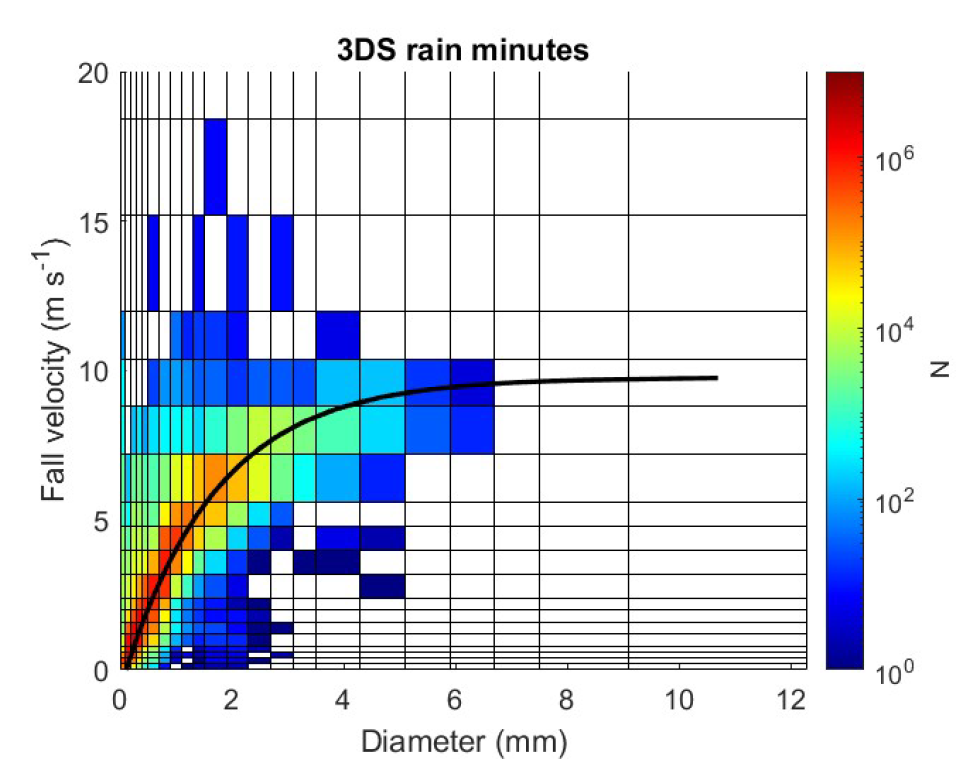
Disdrometric data from a Thies Clima 3D Stereo with 22 size classes and 20 velocity classes positioned at L'Aquila (Italy, 42.3831 N, 13.3148 E, 683 m a.s.l.), with monthly spectra and ancillary information.
-
The larval stages can be considered as the link from plankton to benthos. In order to study larval recruitment from zoobenthos, 40 tiles were placed at each of the four sites outlined in the project: Tethys Bay (control), Rod Bay (area subject to anthropogenic impact), Faraglione (control) and Adelie Cove (area subject to natural impact, linked to the presence of a penguin house). Due to adverse environmental factors all the tiles from Faraglione were lost and from Tethys Bay only half were found. The tiles were analysed with the help of a binocular, which enabled better visualisation of the organisms and, consequently, better identification.
-
Here we present the firn cores collected along the international EAIIST project traverse, which took place in 2019-2020 Antarctic Campaign. We report the number of firn cores collected, the depth of the samplings and their geographic information.
-
Calibrated (in unit of solar disk brightness) measurements of the sky brightness at DOME C as obtained by the ESCAPE experiment during the campaign 2018-2019
-

The fungal communities in rocks and soils of three different localities (Battleship Promontory, Richard Nunatak, Trio Nunatak), where stations are collecting climatic data, have been compared with a DNA metabarcoding approach. The results showed a strong differentiation in the communities diversity and composition between the two substrates, with an higher diversity in soils compared to rocks.
-
Surface ozone data, collected through a UV-absorption analyzer (49i or 49c)
-
Antarctic ecosystems have a high number of species, that are closely linked to the presence of sea ice and seasonal cycles. This biodiversity is subject to anthropogenic and natural influences. Zooplankton communities can provide a static snapshot of the health of the ecosystem. Zooplankton samples were collected with a 200 μm mesh net at 3 different sampling points at 80 m depth.