climatologyMeteorologyAtmosphere
Type of resources
Topics
INSPIRE themes
Keywords
Contact for the resource
Provided by
Years
Formats
Representation types
Update frequencies
status
Scale
-
The lidar observatory at Mcmurod, was one of the primary stations of the NDACC network (Network for the Detection of Atmospheric Composition Change) from 2004 to 2010. The lidar observes polar stratospheric clouds at a height between 12 and 26 km typically, from early June until the end of Settember. These PSCs play an important role in the ozone chemistry and promote the depletion of the stratospheric ozone layer. The lidar can detect even very thin PSC layers and can provide important information about their chemical composition. The lidar can be used to study formation and dynamical processes and to provide long term records useful for climate studies.
-
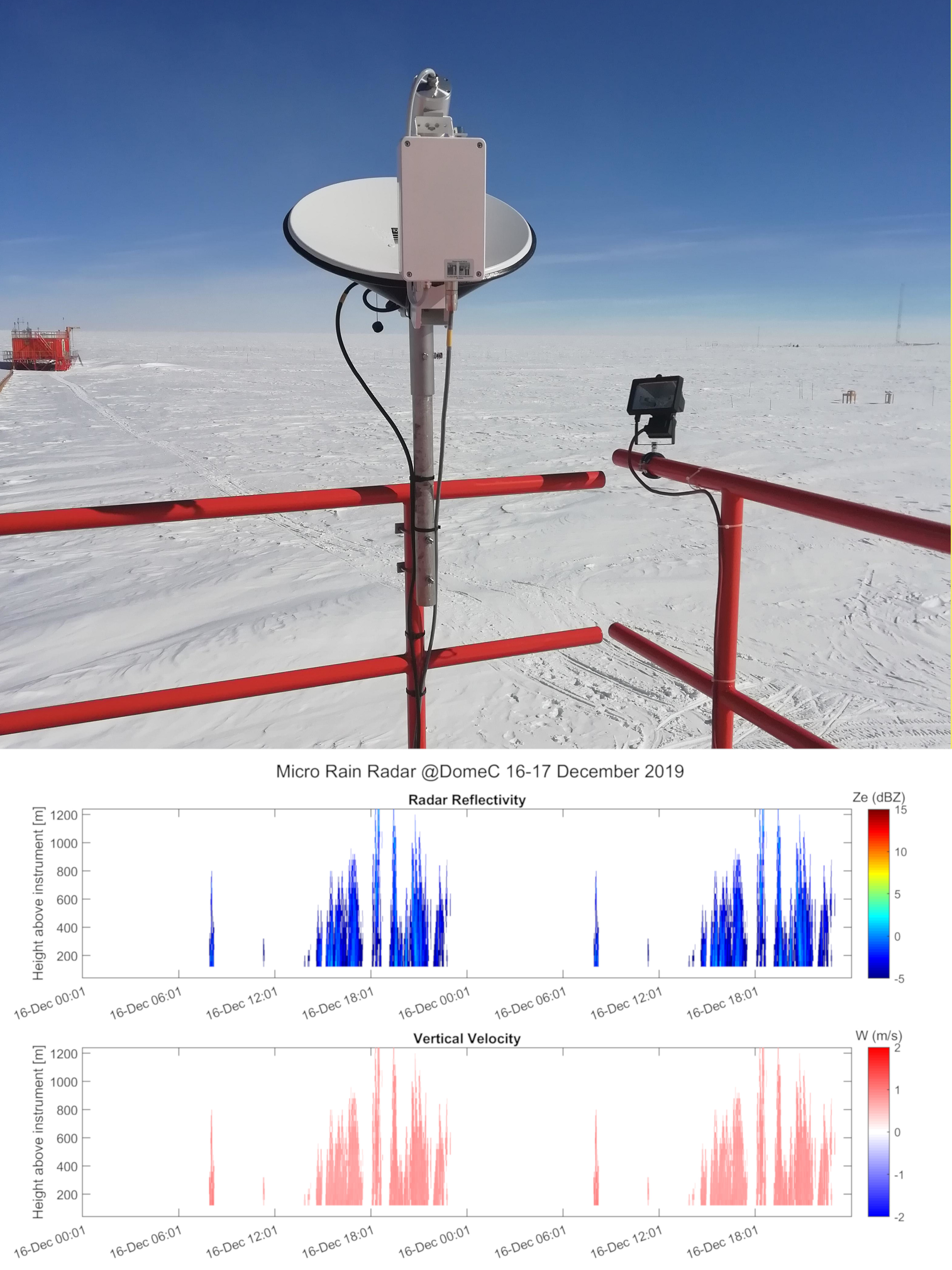
Vertical profiles along the first three kilometres of atmosphere above the ground (from 300 to 3000 m a.g.l.) of equivalent radar reflectivity factor (Ze), Doppler velocity (W) and Doppler spectral width (Sw) from a 24-GHz vertically pointing Micro Rain Radar MRR-2 by METEK GmbH positioned at Concordia Station (Dome C, Antarctica). The main objective of the FIRCLOUDS project is a complete spectral characterization of cirrus and mixed phase clouds in order to evaluate the radiative models in the FIR regime, where the clouds effect is very strong, and systematic spectral measurements are scarcely available. The micro rain radar (MRR) data allows the determination of the clouds reflectivity and the vertical velocity of ice crystals in the cases of precipitating clouds.
-
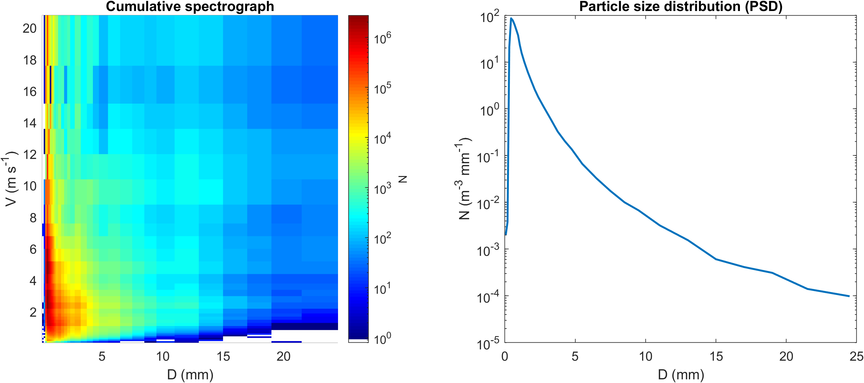
Disdrometric data from an OTT Parsivel with 32 size classes and 32 velocity classes positioned at Mario Zucchelli Station (Antarctica), with monthly spectra and particle size distributions (PSD).
-

Pictures of the ice camera and the halo camera positioned at Concordia Station (Dome C, Antarctica). Data are available on the INO-CNR server on request to Dr. Massimo Del Guasta. The main objective of the FIRCLOUDS project is a complete spectral characterization of cirrus and mixed phase clouds in order to evaluate the radiative models in the FIR regime, where the clouds effect is very strong, and systematic spectral measurements are scarcely available. The ice and halo imager cameras enable an assessment of the cloud ice crystals micro-physics.
-
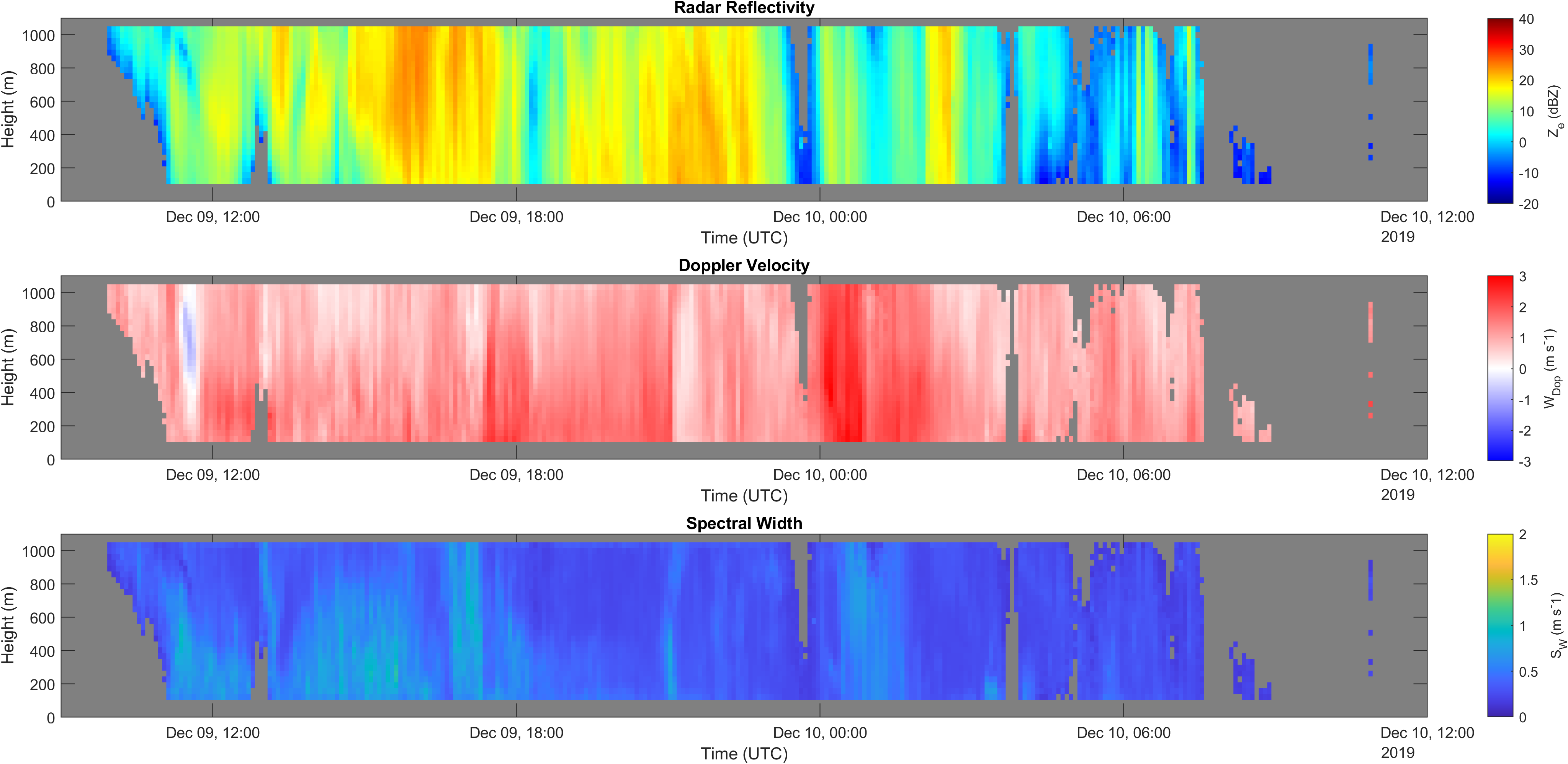
Vertical profiles along the first kilometre of atmosphere above the ground (from 105 to 1050 m a.g.l.) of equivalent radar reflectivity factor (Ze), Doppler velocity (W) and Doppler spectral width (Sw) from a 24-GHz vertically pointing Micro Rain Radar MRR-2 by METEK GmbH positioned at Mario Zucchelli Station (Antarctica).
-
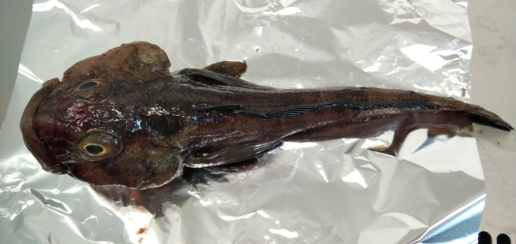
Anthropogenic microparticles (AMs) were found for the first time in specimens of Trematomus bernacchii collected in 1998 in the Ross Sea (Antarctica) and stored in the Antarctic Environmental Specimen Bank. Most of the identified AMs were fibers of natural and synthetic origin. The natural AMs were cellulosic, the synthetic ones were polyester, polypropylene, polypropylene/polyester, and cellulose acetate. The presence of dyes in the natural AMs indicates their anthropogenic origin. Five industrial dyes were identified by Raman spectroscopy with Indigo occurring in most of them (55%). Our research not only adds further data to the ongoing knowledge of pollution levels in the Antarctic ecosystem, it provides an interesting snapshot of the past, highlighting that microplastics and anthropogenic fiber pollution had already entered the Antarctic marine food web at the end of the ‘90 s. These findings therefore establish the foundations for understand the changes in marine litter pollution over time.
-
The current vision of global climatic changes stresses on the interlinked action of many factors, often more evident at regional scales. Polar regions are among the areas most sensitive to perturbations of the climate: through connections involving ocean, atmosphere, biosphere, lithosphere and cryosphere, they respond to, amplify, and drive changes elsewhere in the Earth system, so that understanding their role is essential. Peculiar characteristics of Polar Regions contribute to modify the energy and radiation budget, and the characteristics of the polar atmospheric boundary layer (ABL), increasing relevance at regional level of coupling processes between components of the climate system, especially in the coastal region. In particular, the long polar night, the sea-ice and snow coverage, favouring the persistency of stable atmospheric conditions, and the local and mesoscale circulation interactions, all affect the status and variability at different time scales of components of the regional climate system. Predicting future conditions of the polar regions is the goal of the Polar Prediction Project and of one of its key elements, the Year of Polar Prediction (YOPP, http://www.polarprediction.net/yopp.html), scheduled to take place from mid-2017 to mid-2019). This requires the scientific knowledge of their present status as well as a process-based understanding of the mechanisms of change. The parameterization of physical processes in regional and global hydrodynamical numerical models of the atmosphere is not yet enough accurate for a correct representation of all components of the climatic system and of their connections, the knowledge of which is needed to determine the role of polar regions in the global climate. As an example, more extended and integrated dataset are required to improve the parameterization of the ABL, for complex orography areas such as the polar coastal regions. The general scope of this project is to improve the understanding of the surface-atmosphere mass and energy exchanges at an Antarctic coastal site in the Ross Sea through continuous and accurate measurements of the atmospheric parameters, and development and verification of multiscale modelling, and through these activities, to address some of the relevant questions included in the roadmap for Antarctic and Southern Ocean science for the next two decades and beyond. Measurements will be carried out year-round at the new Korean Jang Bogo Antarctic Research Station (JBS), located at the coast of Terra Nova Bay, in the vicinity of the Italian Mario Zucchelli Station. Measurement and analysis of radiation components, atmospheric constituents and energy fluxes, meteorological and micrometeorological parameters, will be implemented jointly by Korea Polar Research Institute (KOPRI), CNR and UNIFI, in a way similar to the collaboration already active in the Arctic. Such implementation will be very useful to close a gap in the global climate observation system (GCOS) and contribute to WMO programs providing scientific data and information on meteorological and radiation regimes, vertical structure and chemical composition of the atmosphere.
-
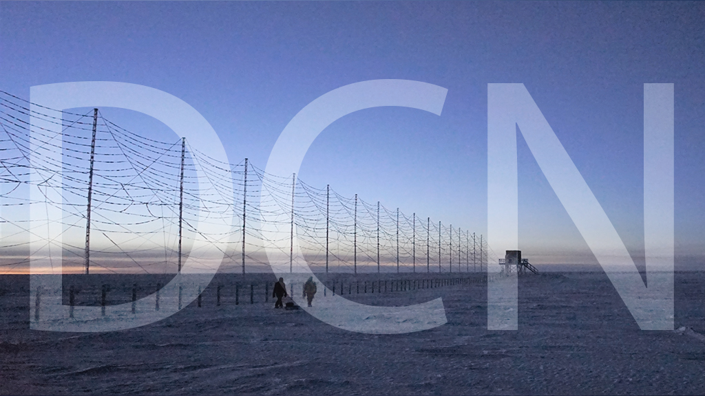
The HF radar denominated Dome C North (DCN) emits pulses of HF waves (8–20 MHz) which are refracted in the ionosphere and can be back-scattered by field aligned decameter scale irregularities of the electron density at distances ranging from 180 to 3550 km from the radar and at heights between 100 and 400 km. The radar signals are steered in 16 emission beams, separated by 3.3 degrees, in an azimuthal interval of 52 degrees, usually swept in 2 minutes. The signals are emitted according to multi-pulse sequences that allow the real-time acquisition of the autocorrelation function of the back scatter echoes, from which the reflected power, the VD Doppler velocity of the irregularities, and the spectral width can be calculated for each distance-azimuth cell. VD coincides with the velocity of the plasma along the line of sight. DCN is part of the Super Dual Auroral Radar Network (SuperDARN). In SuperDARN, pairs of radars, typically located at 2000 km distance and oriented so that their beams cross each other over the region to be studied, are used to get the velocity vector in two dimensions. DCN forms a common-volume pair with the SuperDARN Zhongshan radar (China). SuperDARN radars are devoted to the study of ionosphere, between 100 and 400 km from ground, in the polar, auroral and medium latitude regions. The sscientific objectives of SuperDARN and DCN span from fundamental plasma physics to space weather, in the framework of Sun-Earth relations. Italy participates in the SuperDARN international network also with the Dome C East (DCE) radar,installed at Concordia in 2013 and operative since then.
-
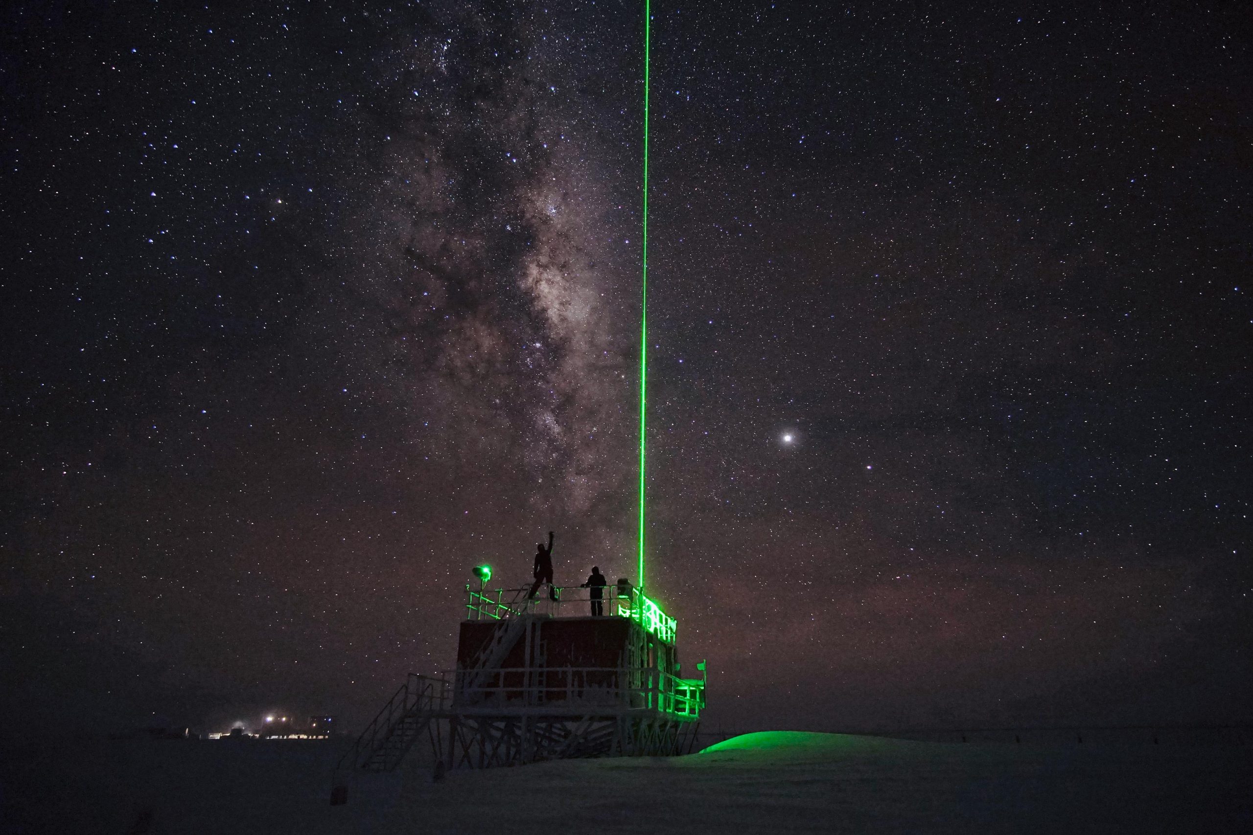
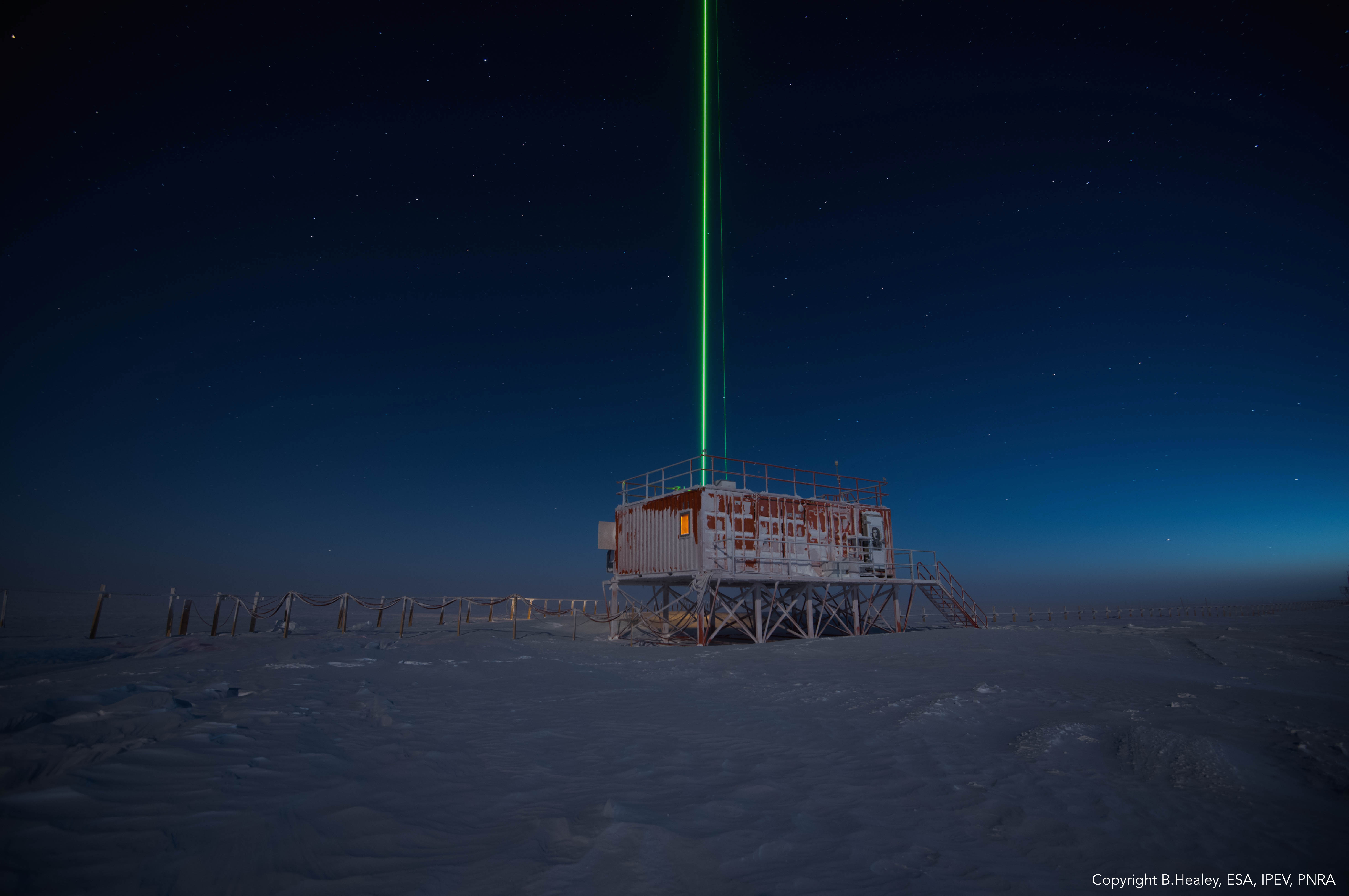
The lidar observatory at Dome C, Concordia station, is one of the primary stations of the NDACC network (Network for the Detection of Atmospheric Composition Change). Since 2014 the lidar observes polar stratospheric clouds at a height between 12 and 26 km typically, from early June until the end of Settember. These PSCs play an important role in the ozone chemistry and promote the depletion of the stratospheric ozone layer. The lidar can detect even very thin PSC layers and can provide important information about their chemical composition. The lidar can be used to study formation and dynamical processes and to provide long term records useful for climate studies.
-
Emerging COntaminants in Antarctic Snow: sources and TRAnsport (ECO AS:TRA) Prog. PNRA18_00229 Snow samples