Atmospheric conditions
Type of resources
Topics
INSPIRE themes
Keywords
Contact for the resource
Provided by
Years
Formats
Representation types
Update frequencies
status
Scale
-
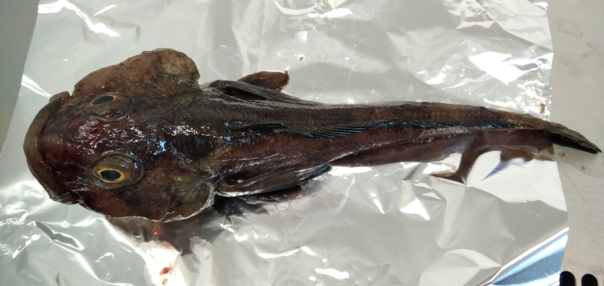
Anthropogenic microparticles (AMs) were found for the first time in specimens of Trematomus bernacchii collected in 1998 in the Ross Sea (Antarctica) and stored in the Antarctic Environmental Specimen Bank. Most of the identified AMs were fibers of natural and synthetic origin. The natural AMs were cellulosic, the synthetic ones were polyester, polypropylene, polypropylene/polyester, and cellulose acetate. The presence of dyes in the natural AMs indicates their anthropogenic origin. Five industrial dyes were identified by Raman spectroscopy with Indigo occurring in most of them (55%). Our research not only adds further data to the ongoing knowledge of pollution levels in the Antarctic ecosystem, it provides an interesting snapshot of the past, highlighting that microplastics and anthropogenic fiber pollution had already entered the Antarctic marine food web at the end of the ‘90 s. These findings therefore establish the foundations for understand the changes in marine litter pollution over time.
-
The ideal site for the measurement of solar and terrestrial radiation for meteorological purposes is one that has a completely flat horizon. The WMO Guide to Meteorological Instruments and Methods of Observation (WMO No. 8) recommends that if possible no obstruction should be present, particularly within the azimuth range of sunrise and sunset over the year. This dataset describes the horizon at the BSRN radiation site DOM as additional information on the site's surroundings.
-
Emerging COntaminants in Antarctic Snow: sources and TRAnsport (ECO AS:TRA) Prog. PNRA18_00229 Snow samples
-
Calibrated (in unit of solar disk brightness) measurements of the sky brightness at DOME C as obtained by the ESCAPE experiment during the campaign 2019-2020
-
PM10 time series at Concordia
-
Calibrated (in unit of solar disk brightness) measurements of the sky brightness at DOME C as obtained by the ESCAPE experiment during the campaign 2022-2023
-
Calibrated (in unit of solar disk brightness) measurements of the sky brightness at DOME C as obtained by the ESCAPE experiment during the campaign 2018-2019
-
The DoCTOr (Dome C Tropospheric Observer) project aims to establish an integrated monitoring system to measure simultaneously, continuously and with a high temporal resolution the water vapor and temperature vertical profiles and the radiative exchanges vs. altitude. The monitoring will enable us to detect both long-term trends and fast-evolving phenomena, the latter useful in the interpretation of the causes of the first. This task is performed mainly through remote sensing techniques, allowing for the study of a highly unperturbed atmospheric sample. The integration of all the deployed instrumentation in a single acquisition system simplifies greatly the data analysis needed to retrieve the final products: The REFIR-PAD spectroradiometer (already operating in dome C since 2011) will provide spectrally-resolved atmospheric downwelling radiances in the mid to far-infrared spectral range, while a laser diode based profiler will characterize the microphysics state of the first 3 km of the atmosphere.A real-time data analysis system based on an atmospheric radiative transfer model will then retrieve from the acquired data the temperature and water vapor profiles and the cloud optical thickness in almost all weather conditions found at Dome C, with a temporal resolution of about 10 minutes.
-
Calibrated (in unit of solar disk brightness) measurements of the sky brightness at DOME C as obtained by the ESCAPE experiment during the campaign 2021-2022
-

The knowledge of properties and quantitative measurement of solid precipitation in Antarctica is of fundamental importance as precipitation represents the main input of Antarctic ice sheet mass, the variations of which have a direct and non-negligible effect on the average level of the oceans at global scale. Characterization and quantification of the precipitation is crucial in defining and validating global climate models and numerical weather prediction models, as well as anchoring and validating space-borne remote sensing estimates from missions like CloudSAT and EarthCARE. A snow and cloud microphysics observatory has been set up at the Italian Antarctic station Mario Zucchelli (MZS), integrating the pre-existing instrumentation for weather measurements. In particular, a 24-GHz vertical pointing Doppler radar, the METEK's Micro Rain Radar 2 (MRR-2), and a laser disdrometer, the OTT Parsivel, have been integrated with the advanced weather stations, radiosoundings and the ceilometer already present at MZS. The synergy between the set of instruments allows for characterizing precipitation and studying properties of Antarctic precipitation such as dimension, shape, fall behavior, particle number density, particles size distribution, particles terminal velocity, reflectivity factor and information on their vertical extent. APP started as a four-year project in July 2017, covering the Special Observation Period (SOP) in the Southern Hemisphere of Year of Polar Predicition (YOPP) period. APP can provide specific measurements for precipitation occurring over the Antarctic coast at high temporal resolution, in particular specific snow products such as snow rate, snow depth and their water equivalent. In November 2023 the observatory received an additional instrument, the Thies Clima 3D Stereo imaging disdrometer, which was previously installed for one year in Italy for testing, at the Casale Calore (AQ) meteorological observation site from the University of L'Aquila. The research team of the first two years was coordinated by Nicoletta Roberto, with operational units at the Rome unit of the CNR-ISAC (Luca Baldini, Elisa Adirosi, Stefano Dietrich) and at the Department of Physics and Astronomy of the University of Bologna (Rolando Rizzi, Federico Porcù, Tiziano Maestri, Alessandro Bracci). From 2020 the coordination of the project passed to Luca Baldini (CNR-ISAC) and the work team was extended with the research fellows Giacomo Roversi and Sabina Angeloni.